


Semois: Hautes rivières-Thilay boucle

renneph
User
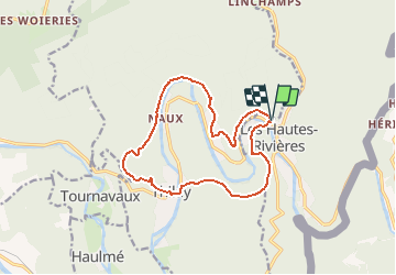

Length
13.1 km

Max alt
342 m

Uphill gradient
390 m
Km-Effort
18.4 km

Min alt
151 m

Downhill gradient
394 m
Boucle
Yes
Creation date :
2020-07-16 09:51:46.112
Updated on :
2020-08-07 09:20:55.183
6h30
Difficulty : Very difficult

FREE GPS app for hiking
 SityTrail
IGN / Geographical institutes
SityTrail Plus
The world is yours!
About
Trail Walking of 13.1 km to be discovered at Grand Est, Ardennes, Les Hautes-Rivières. This trail is proposed by renneph.
Positioning
Country:
France
Region :
Grand Est
Department/Province :
Ardennes
Municipality :
Les Hautes-Rivières
Location:
Unknown
Start:(Dec)
Start:(UTM)
632152 ; 5527802 (31U) N.
Comments